History of Flood Control for Sacramento
-
2020 – Current
2025
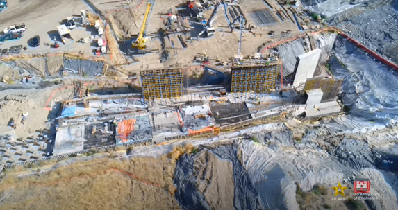
Going into new year there are 11 major contracts under construction by the Corps of Engineers rebuilding the system protecting Sacramento from flooding. These include four major construction contracts at Folsom Dam, four major construction contracts rebuilding the levees protecting the Natomas Basin, two major contracts along the lower American River, and continued work on widening the Sacramento Weir and Bypass.
2024
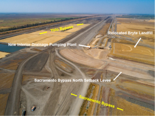
The California Department of Water Resources completes construction of the Lower Elkhorn Basin Levee Setback Project which includes widening the Sacramento Bypass and widening the east side of the Yolo Bypass along the Lower Elkhorn Basin. This works provides significant flood risk reduction for the Sacramento area.
2024
The Corps of Engineers hosts a “Sacramento Basin Flood Risk Management Showcase” to increase awareness of the more than $5 billion in ongoing flood risk reduction projects in the Sacramento Region. Congresswoman Doris Matsui and Assistant Secretary of the Army (Civil Works) Michael Connor spoke.
2023
Sacramento hosted the Annual Meeting of the National Waterways Conference bringing together Federal officials, industry representatives, water agencies, and organizations from across the country. By hosting the meeting in Sacramento, the participants now better understand the flood risk to Sacramento and were able to see first-hand the importance of having the Federal improvements being made to Sacramento’s flood risk reduction system.
2023
The Corps of Engineers initiates work on widening the Sacramento Weir.

2023
The Corps of Engineers continues work on the Folsom Dam Raise projects by initiating construction on raising the Right and Left Wing Dams, Dikes 1 through 6, and strengthening and top sealing the Main Dam gates and concrete piers.

2023
The new auxiliary spillway at Folsom Dam is used for the first time during a flood event.

2023
The Corps of Engineers awards almost half a billion dollars in new construction contracts in the first four months of the 2023.
2023
Federal funding provided to initiate the comprehensive study of the Yolo Bypass.
2022
Funding was obtained through the Infrastructure Investment and Jobs Act for the Corps of Engineers to automate and improve the Temperature Control Shutters at Folsom Dam, which regulate the release of cold water for the downstream fisheries.

2022
The State of California released the Central Valley Flood Protection Plan Update which serves as a long-range plan that guides the State’s participation in managing flood risk in the Central Valley.
2022
The Corps of Engineers initiates bank and levee erosion work along the Sacramento River below south of the American River required to safely handle large flood flows.

2022
The Corps of Engineers initiates bank and levee erosion work along the lower American River designed to increase the channel capacity from 115,00 cfs to 160,000 cfs to be able to safely handle larger flood events.

2021
California SB-369 is enacted into law codifying in State law the Yolo Bypass and Cache Slough Partnership.
2020
The Water Resources Development Act of 2020 is enacted into law. It includes authorization for a new, comprehensive and multi-benefit study of improvements needed to the Yolo Bypass.
2020
SAFCA awards construction contracts for internal drainage and a pump station required for the Lower Elkhorn Basin Levee Setback Project.

2020
The State of California initiates construction of the Lower Elkhorn Basin Levee Setback Project which includes widening the Sacramento Bypass (part of the Congressionally authorized work) and widening the east side of the Yolo Bypass along the Lower Elkhorn Basin.

2020
After final Federal approvals, SAFCA completes acquisition of a portion of the Sierra Northern Railroad that needs to be moved in order to widen the Sacramento Weir and Bypass.
2020
After final Federal approvals, SAFCA completes acquisition of a portion of the Sierra Northern Railroad that needs to be moved in order to widen the Sacramento Weir and Bypass.
-
2010 – 2019
2019
With financial backing from the State of California SAFCA completes the remediation of the old Bryte Landfill, which needed to be relocated to widen the Sacramento Bypass.

2019
The Corps of Engineers initiates construction of the Folsom Dam Raise by working on Dike 8.

2019
SAFCA celebrates its 30th anniversary in a ceremony that also honors Congresswoman Doris Matsui for her accomplishments in securing Federal resources to improve Sacramento flood control.
2019
The Corps of Engineers initiates reconstruction of the Sacramento River levees downstream of the mouth of the American River.

2019
The new Folsom Dam Water Control Manual detailing the new forecast informed flood control operation is executed. This new operation provides significantly more flood risk reduction than the previous operations, as well as benefits other reservoir purposes such as water supply and cold water for downstream fisheries.
2018
Congress passes the Bipartisan Budget Act of 2018 and $1.8 billion is provided to construct levee and erosion work authorized by Congress in 2016, as well as to widen the Sacramento Weir and Bypass and to raise Folsom Dam by 3.5 feet for additional flood control.
2018
The Corps of Engineers initiates reconstruction of the remaining levees protecting the Natomas Basin.

2017
The new dam and auxiliary spillway constructed as part of the Folsom Dam Joint Federal Project is complete and operational.

2017
SAFCA presents its Comprehensive Flood Risk Reduction Program for the Sacramento area with the goal of achieving 500-year level of protection. The purpose is to help address potential increased flood risk due to climate change by introducing more resiliency and flexibility in the system.
2017
With financial assistance from the State of California SAFCA initiates the North Area Streams Project to advance reconstructing the levees along the eastside tributaries in north Sacramento while awaiting Congressional authorization for the Corps of Engineers to construct the project.

2017
The State of California released the Central Valley Flood Protection Plan Update which serves as a long-range plan that guides the State’s participation in managing flood risk in the Central Valley.
2016
The Yolo Bypass and Cache Slough Memorandum of Understanding was executed by 15 agencies (including SAFCA) to serve as the vehicle to promote the discussion, prioritization, and resolution of policy and other issues critical to the success of the various planning efforts In the Yolo Bypass.
2016
Sacramento area property owners approve a new consolidated flood control assessment to finance the additional work authorized by Congress to increase flood protection for the region. The previously established capital assessment district is dissolved.
2016
Congress authorizes work on the remaining portion of the levee system protecting Sacramento not covered under previous authorizations to include up to 11 miles of bank and levee erosion protection on the American River, up to 10 miles of bank and levee erosion protection on the Sacramento River, up to 9 miles of slurry cutoff walls to address levee underseepage on the Sacramento River and up to 4 miles of slurry cutoff walls to address levee underseepgae along the eastside tributaries in the north area of Sacramento. The authorization also includes widening the Sacramento Weir and Bypass to allow the system to handle larger flood events. The authorization includes the work previously initiated by SAFCA.
2016
Levee and channel work along the tributaries in south Sacramento is complete.

2016
SAFCA entered into agreements with the United Auburn Indian Community identifying procedures, protocols and processes to identify, protect, avoid, monitor, and treat Tribal cultural resources in a culturally appropriate and respectful manner since much of the upcoming levee work would occur in culturally sensitive areas.
2016
Levee work along both sides of the American River to address underseepage and stability issues is complete.

2015
FEMA maps the Natomas Basin into an A99 zone, lifting some of the building restrictions, but not the flood insurance requirements.
2015
SAFCA was staffed since its founding with positions held by the City and County of Sacramento. Changes in the Internal Revenue Code (IRC) no longer allowed for more than one agency to participate in the same deferred retirement plan. In 2015 SAFCA left the city and county personnel systems and began its own.
2014
The Lower Sacramento River/Delta North Regional Plan is released. It focused on a geographic area which includes portions of Solano, Yolo, Sacramento, and Sutter Counties. Its goal is to develop the long-term vision for sustainable, integrated flood management in the Region through a collaborative process involving regional stakeholders.
2014
Congress authorizes reconstructing 42 miles of levees protecting the Natomas Basin of Sacramento Natomas. The levees are to be reconstructed to meet the new urban levee standards. The authorization includes the work previously completed by SAFCA.
2013
Corps withdraws accreditation of all the levees in Sacramento outside the Natomas Basin because they do not meet new urban levee standards.
2012-2013
SAFCA completes the Natomas Levee Improvement Program, reconstructing 18 miles of levees.

2012
The State of California released the Central Valley Flood Protection Plan which is California’s strategic blueprint to improve flood risk management in the Central Valley. With the release of the CVFPP, the State also initiated preparation of six regionally-led Regional Flood Management Plans that describe local and regional flood management priorities and challenges. SAFCA participated as part of the Lower Sacramento River/Delta North Region.
2011
Natomas Basin property owners approve a Natomas Basin assessment district to raise additional funding to reconstruct the Natomas Basin levees to the new urban standards. This assessment district supplements the existing capital assessment district.
-
2000 – 2009
2009
The Folsom Lake Crossing Bridge is completed. The bridge was constructed to remove traffic off the top of Folsom Dam in order to allow for flood control improvements at Folsom Dam.

2008
Construction begins on Folsom Dam Joint Federal Project, with the main feature being a new dam and a gated auxiliary spillway designed to allow Folsom Dam to safely pass larger flood events.

2008
SAFCA Board approves a Development Impact Fee Program designed to offset the effect of future floodplain development with more flood system improvements.
2008
FEMA maps the Natomas Basin back into the 100-year floodplain based on the Corps of Engineers findings. This imposes some building restrictions and mandatory flood insurance requirements.
2007
Congress approves changing the previously authorized modifications to the outlet works at Folsom Dam to construction of a new dam and auxiliary spillway at Folsom Dam.
2007
New State laws enacted to implement better flood management policies and practices, including land use, environmental enhancement, and new flood control facilities. The new legislation requires that urban areas in the central Valley of California have a system that can safely pass a 200-year flood by 2025.
2007
Sacramento area property owners within the 200-year floodplain approve a consolidated flood control assessment to finance the local share of the costs for SAFCA’s plan to achieve 200-year flood protection for the region. The two previously established capital assessment districts are dissolved.
2007
Improvements to Sacramento River levees, including deep under-seepage cutoff walls and erosion protection, as well as improvements to South Sacramento Streams levees provide 100-year flood protection for the Meadowview and Pocket communities.
2007
With financial assistance from the State of California SAFCA initiates the Natomas Levee Improvement Program to advance reconstructing the Natomas Basin levees while awaiting Congressional authorization for the Corps of Engineers to construct the project.

2006-2007
Based on the new levee standards for urban area, the Corps of Engineers determines that the Natomas basin has significantly less than a 100-year level of protection.
2004-2007
After reviewing levee failures during the 1997 California Central Valley Flood and the 2005 Katrina Flood, new standards for levees protecting urban areas are established to better address levee seepage and stability concerns.
2006
California voters approve Proposition 1E to finance flood system improvements with $4.1 billion in bonds.
2005
Hurricane Katrina hits New Orleans. The flooding of New Orleans occurred from levee failures. This was a wake-up call for urban areas. The Sacramento area is identified as one of the most at-risk urban areas in the country from riverine flooding.
2005
Improvements to American River levees, including deep under-seepage cutoff walls and erosion protection and operational improvements for Folsom Dam provide 100-year protection for much of the American River Floodplain, except the Pocket and Meadowview communities.
2004
Congress authorizes Raising Folsom Dam to provide additional space to control floods. As part of this, Congress also approves construction of a new bridge downstream of Folsom Dam, modifications of the existing temperature control shutters at Folsom Dam, and downstream improvements for ecosystem restorations at sites along the lower American River.
2000
Sacramento property owners vote to impose a flood control assessment to finance the local match for the flood control projects for the American River and South Sacramento approved by Congress in 1996 and 1999.
-
1990 – 1999
1999
Congress Approves Significant Sacramento Flood Control Projects: Projects include increasing release capacity at Folsom Dam, raising the lowest levees on the American River, and raising levees along Morrison creek and its tributaries in South Sacramento. Congress also authorized examining a new operation for Folsom Dam flood control based on a forecast informed operation.
Construction of seepage cutoff walls and other levee improvements along Lower American River begins.

1998
Work on SAFCA’s North Area Local Project, begun in 1993, progresses to the point where the Corps of Engineers and FEMA certify that Natomas and portions of North Sacramento have 100-year protection and flood insurance is no longer required.
1997
Record Flood: The fifth record flood in 46 years occurs over the New Year’s holiday. Unprecedented flows from rain and melted snow surge into the Feather and the San Joaquin. Sacramento is spared when the fury of the storm hits 40 miles north in the Feather River. Levee failures flood Olivehurst, Arboga, Wilton, Manteca, and Modesto. Sacramento experiences significant levee problems in the Sacramento area.

1996
Congress does not approve a dam at Auburn: The Corps of Engineers again recommends a Dam at Auburn. The project is rejected in a House committee. American River levee improvements are authorized.
1994
Folsom Dam Operation Improved: SAFCA and the Bureau of Reclamation execute an agreement to operate Folsom Dam and Reservoir to take advantage of incidental flood control provided by upstream water and power reservoirs at French Meadows, Hellhole, and Union Valley.
1993
SAFCA Initiates Construction of the North Area Local Project: Following Congress action in 1992, SAFCA begins construction on levee improvements to protect North Sacramento and Natomas, completed 1998.
1992
Congress does not approve a Dam at Auburn: 6 years after the 1986 flood, the Corps of Engineers recommends a flood control dam at Auburn. The project is defeated on the House floor. Levee improvements in North Sacramento and Natomas are approved.
1990-1993
Corps Constructs Sacramento Area Urban Levee Improvements along Sacramento River, Verona to Freeport.
-
1840 – 1989
1989
SAFCA Formed: In October of 1989, the Sacramento Area Flood Control Agency holds its first public meeting.
1986
Record Flood: The February 1986 storm dumps 10 inches of rain on Sacramento in 11 days. The American River dumps more water into Folsom than it is designed to handle. After 2 days of releases at the design level, (115,000 cubic feet per second (cfs)), officials boost releases to 134,000 cfs. Folsom performance downgraded to about a 60-year storm. The system experiences significant levee problems in the Sacramento area.

1964
Record Flood: The third record flood in less than 15 years causes engineers to re-evaluate storm frequency. They conclude the storm Folsom is designed to handle is a 120-year storm not a 500-year storm.
1956
Record Flood: Though engineers had been predicting it would take a year to fill the nearly completed Folsom Dam, the second record storm filled the dam in a week and Sacramento is saved from flooding.
1951
Record Flood: Just after ground is broken on Folsom Dam, the American River watershed experiences the first of five record storms.
1944
Folsom Dam Authorized: The Flood Control Act of 1944 authorized the U.S. Army Corps of Engineers (Corps) to build a dam on the lower American River. Completed in 1956, Folsom Dam was originally designed to provide in excess of a 500-year level of flood protection.

1929
Fremont Weir completed.
1917
Congress authorizes Sacramento Flood Control System: After a series of violent floods between 1902 and 1909, the Comprehensive flood control project envisioned by Hall gained federal financial authorization in 1917.
1916
Sacramento Weir completed.
1880
First Comprehensive Flood Control Plan: In response to the 1878 flood, State Engineer William Hammond Hall developed an integrated, comprehensive flood control plan for the Sacramento Valley. The plan subsequently came to include a system of levees, weirs and bypass channels to protect existing population centers.
1864-1868
American River Rechannelized: In an effort to create faster flows that might scour out mining debris, Sacramento officials straightened the last two miles of the American River. When the project was completed in 1868, the American joined the Sacramento River about a mile upstream of its old location.
1862-1872
Sacramento Streets Raised: In response to floods of 1861-1862, streets east of the Sacramento River to about 12th Street were raised as much as 14 feet.
1861-1862
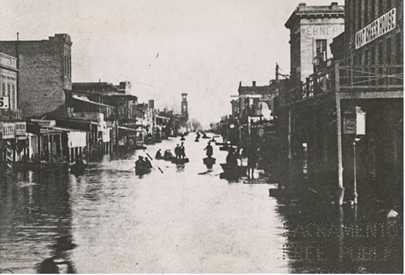
December 9, 1861 – American River Levee failed east of 30th street, flooding what is now known as River Park. The water then overran the City’s levee built to protect it. To relieve the building water levels, the levee at R & 5th Streets was cut to drain the “lake” but houses were swept away in the current in the cut in the levee
January 10, 1862 – Due to flooding, newly elected Governor Leland Stanford had to travel to his inauguration at the Capital in a rowboat.

1840’s
John Sutter settled in Sacramento: He considered the proximity of two mighty rivers (the American and Sacramento) a significant benefit to the fledgling settlement.