American River Watershed Common Features 2016 Project

This project has several components with the goal of reconstructing the remainder of the levee system not covered by other projects and increasing the capacity of the Lower American River Channel to handle larger flood flows.
Once this project is completed, in conjunction with the other projects under construction, the ability of the flood system to handle larger flood events will be significantly improved.
Sacramento River East Levee
The Lower Sacramento River East Levee System is comprised of approximately 12 miles of levee between downtown Sacramento and the Town of Freeport. This levee protects essentially all areas of the City of Sacramento south of the American River and west of Highway 99.
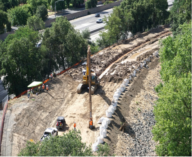
Between 1990-1993, the U.S. Army Corps of Engineers (USACE) constructed 15 miles of levee cutoff walls to address the potential of through seepage during high river flows. An additional 2 miles of cutoff wall work was completed between 2003-2004. However, research and studies conducted following the events of Hurricane Katrina in 2005 found that levees were more susceptible to failure from conditions created by deep under seepage than was previously understood. In light of this finding, State and Federal agencies adopted new policies and standards requiring substantial changes to levee design for urbanized areas.
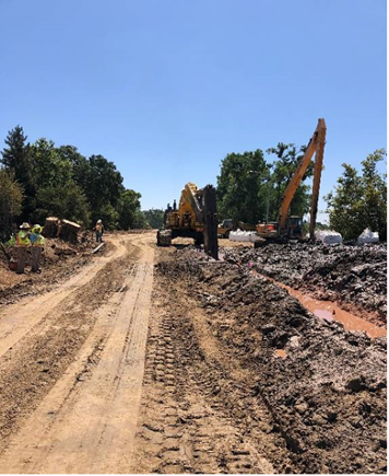
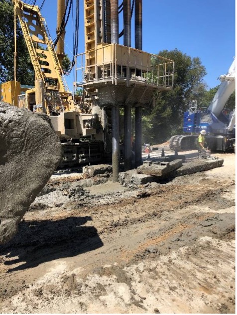
In 2019, the U.S. Army Corps of Engineers (USACE) began constructing levee improvements to address embankment and foundation stability issues caused by deep under seepage and bring the levee system up to modern day standards. In all, it is anticipated that USACE will construct an additional 9 miles of levee cutoff walls. This work is expected to be completed by 2024.
Sacramento River Erosion
USACE is also planning to further strengthen the levee system by constructing erosion protection measures along the river bank. In all, it is anticipated that USACE will construct an additional 10 miles of riverbank erosion protection work. Once completed, the improvements will further reduce flood risk and meet current urban levels of flood protection requirements. This work is expected to be completed by 2025.
North Area Streams
The northern area of Sacramento is protected by a series of levees and channels that include Dry Creek, Robla Creek, Natomas East Main Drain Canal/Steelhead Creek (NEMDC) and Arcade Creek. In the 1990’s, SAFCA implemented substantial improvements to the system. The improvements included construction of a new levee and pump station along the north side of Dry Creek, and levee raising and strengthening along the east side NEMDC, the south side of Dry/Robla Creek, and the north and south sides of Arcade Creek.
In the aftermath of Hurricane Katrina in 2005, State and Federal agencies adopted new policies and standards to make levees safer. It was determined that parts of the system would require additional improvements to meet current standards.
In 2018, SAFCA constructed 3.75 miles of levee improvements along Arcade creek north and south levees west of Marysville Blvd and the NEMDC east levee between Arcade Creek and W El Camino Avenue. Additional improvements to be constructed by the U.S. Army Corps of Engineers are also planned along Magpie Creek. The work is expected to be completed by 2027.
Lower American River Erosion
USACE is planning to construct 11 miles of erosion protection along portions of both the north and south banks of the American River, beginning as early as 2021. Once completed, the cumulative flood control improvements will allow the levee system to safely handle sustained flows of up to 160,000 cubic feet per second in the event of an extreme flood event in the American River watershed. This work is expected to be completed by 2026.
Sacramento Weir and Bypass
The development of a system-wide flood management plan in the Sacramento Valley began around 1850. Up until the flood of 1909, flood management activities focused primarily on confining flows within the existing river channels. This was a period with frequent levee failures, including failures in the 1909 flood event. As a result, the State of California and Federal government decided that a bypass system was needed to divert waters from the main rivers during high flows to relieve stress along the levee system. The State approved the Sacramento and Yolo Bypass systems as part of the Sacramento River Flood Control Project in 1911. Congress then authorized the U.S. Army Corps of Engineers (USACE) to construct the remainder of the project in 1917 and incorporated it into the Federal system.
The Sacramento Weir, completed in 1916, is situated along the right bank of the Sacramento River between the Yolo Causeway and the Garden Highway, approximately 3 miles upstream from the confluence of the American River and Sacramento Rivers. Its primary purpose is to protect the City of Sacramento from excessive flood stages in the Sacramento River by diverting river flows west into the two-mile-long Sacramento Bypass that connects to the Yolo Bypass. The Yolo Bypass takes 80% of the flood flows during storm events from major valley rivers including the Sacramento, American and Feather Rivers.
Just downstream of the Sacramento Weir is the confluence of the American and Sacramento Rivers. The design flood capacity of the American River is higher than that of the Sacramento River. During a major flood event, flows from the American River channel often exceed the capacity of the Sacramento River downstream of the confluence. When this occurs, floodwaters flow upstream from the mouth of the American River to the Sacramento Weir.
USACE, SAFCA and the State of California are planning to widen the Sacramento Weir and Bypass to allow more water to enter into the Bypass system during flood events, thereby reducing the water surface elevation in the Sacramento River. This work includes widening the existing weir by 1,500 feet and constructing a new 2-mile-long setback levee along the Sacramento Bypass.
The first phases of construction began in 2020 when the State initiated construction of the Lower Elkhorn Basin Levee Setback Project, which includes widening the Sacramento Bypass. The USACE will construct the widened weir, which includes a fish passage, and will connect to the levees being constructed by the State. This work is expected to be completed by 2026.
Lower Elkhorn Basin Levee Setback Project
In addition to setting the levees back along the Sacramento Bypass, the State is also setting the levees back along the east levee of the Yolo Bypass from the Sacramento Bypass up to the Interstate 5 crossing. This will further increase the ability of the flood system to handle larger flood events.
Sacramento River East Levee Photos