The City of Sacramento is the most at-risk city in the country from riverine flooding, with more than half a million people in the flood-plain and more than $70 billion in damageable property.
Sacramento is at risk from flooding from both the Sacramento and American Rivers. The flood control system protecting Sacramento was completed in the mid-1950’s. It consist of approximately 106 miles of levees and channels within SAFCA’s jurisdiction. Upstream of Sacramento Folsom Dam controls the flows on the American River. The Sacramento River flows are controlled by the Fremont Weir and Yolo Bypass. Additionally, the Sacramento Weir and Bypass move water into the Yolo Bypass to make room in the Sacramento River for flows coming in from the American River.
The 1986 and 1997 flood events demonstrated that the existing flood control system was extremely undersized. Additionally, Sacramento’s levee system needed to be reconstructed to meet the new urban levee standards promulgated after Hurricane Katrina.
These six projects, costing more than $5 billion, cover reconstructing every portion of the flood control system protecting Sacramento except for the Fremont Weir and Yolo Bypass. These costs are shared by the Federal Government, the State of California and SAFCA.
The U.S. Army Corps of Engineers (USACE) is the Federal Agency responsible for implementing these projects. The U.S. Bureau of Reclamation owns and operates Folsom Dam and cost-shared a portion of the American River Watershed Folsom Dam Modifications Project (Joint Federal Project). The Central Valley Flood Protection Board and the Department of Water Resources are the agencies responsible for implementing and cost-sharing the projects for the State of California. Links to each agencies’ webpage are included.
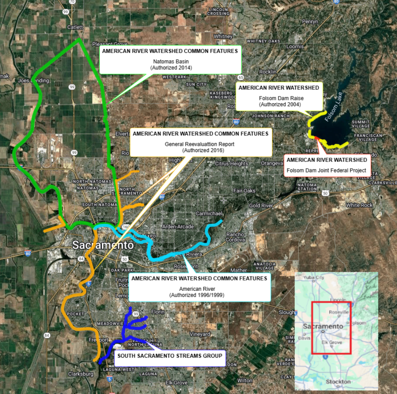
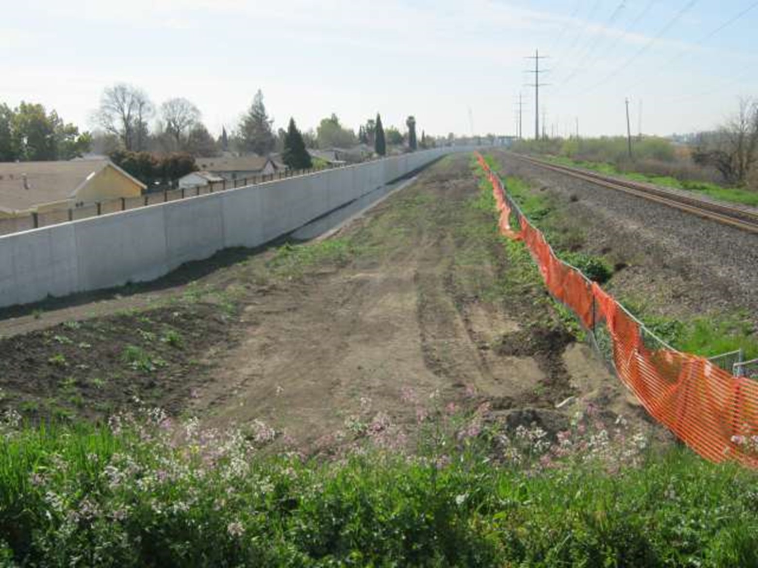
Project map shows the currently active Congressionally-authorized projects under construction.
-
Partnered Agency Pages

U.S. Army Corps of Engineers
https://www.spk.usace.army.mil/

U.S. Bureau of Reclamation
Central Valley Flood Protection Board
California Department of Water Resources
Click here for Interactive Map +
-
American River Watershed Common Features 96/99 Project
The Lower American River Levee System comprises about 25 miles of levees between Folsom Dam and downtown Sacramento. The levees play a crucial role in protecting communities in the Arden-Arcade and North Sacramento areas as well as communities to the south in downtown Sacramento, Land Park, Pocket, Meadowview and South Sacramento. As a result of the flood events of 1986 and 1997, it was recognized that robust improvements were necessary to bring the levee system up to modern day standards.
Between 1998 and 2016, the U.S. Army Corps of Engineers (USACE) installed seepage cutoff walls to depths of 80 feet, raised and stabilized levees, and corrected some erosion problems along 25 miles of the system.
-
American River Watershed Common Features 2016 Project
This project has several components with the goal of reconstructing the remainder of the levee system not covered by other projects and increasing the capacity of the Lower American River Channel to handle larger flood flows.
Once this project is completed, in conjunction with the other projects under construction, the ability of the flood system to handle larger flood events will be significantly improved.
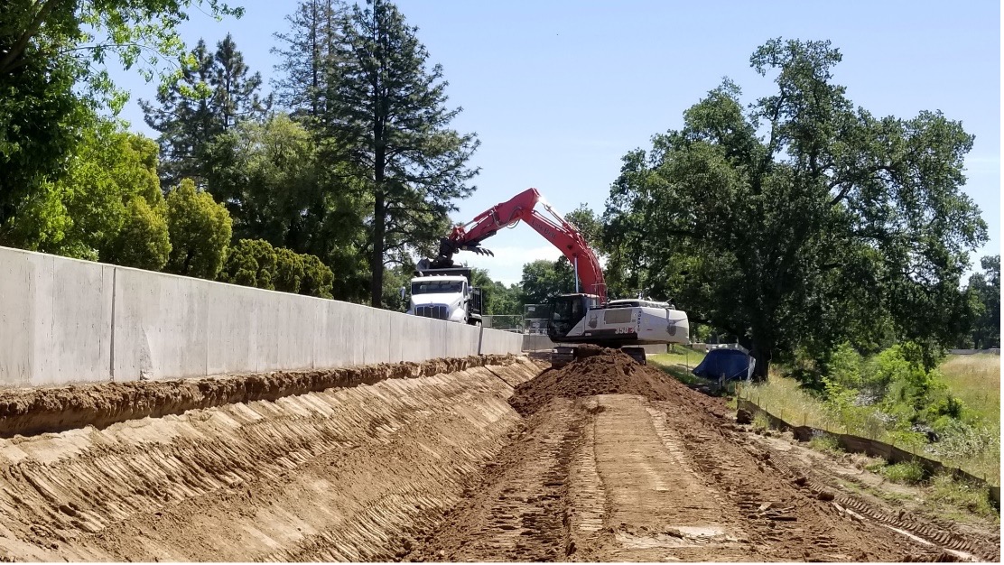
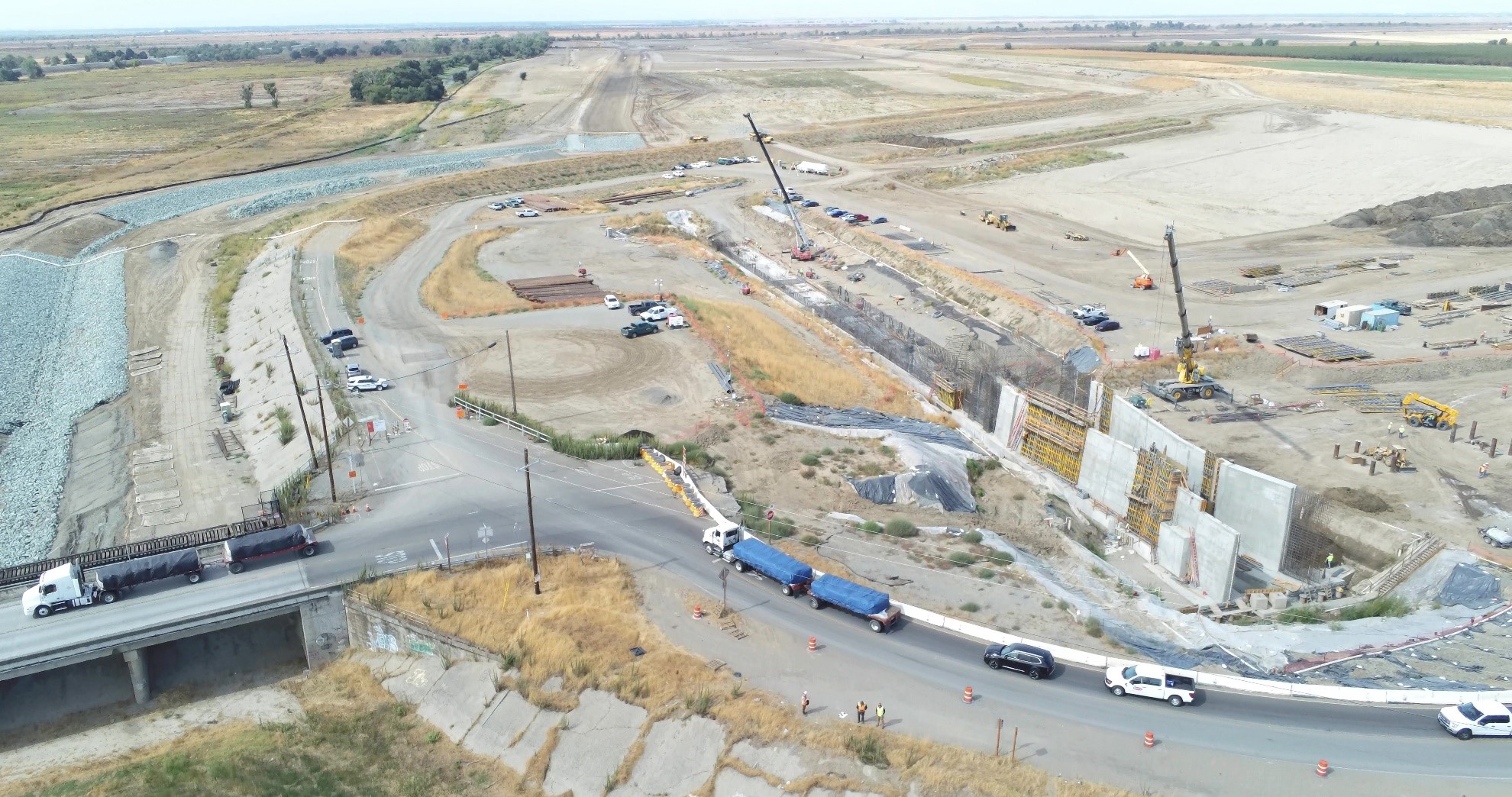
The Lower Sacramento River East Levee System is comprised of approximately 12 miles of levee between downtown Sacramento and the Town of Freeport. This levee protects essentially all areas of the City of Sacramento south of the American River and west of Highway 99.
Between 1990-1993, the U.S. Army Corps of Engineers (USACE) constructed 15 miles of levee cutoff walls to address the potential of through seepage during high river flows. An additional 2 miles of cutoff wall work was completed between 2003-2004. However, research and studies conducted following the events of Hurricane Katrina in 2005 found that levees were more susceptible to failure from conditions created by deep under seepage than was previously understood. In light of this finding, state and federal agencies adopted new policies and standards requiring substantial changes to levee design for urbanized areas.
In 2019, the U.S. Army Corps of Engineers (USACE) began constructing levee improvements to address embankment and foundation stability issues caused by deep under seepage and bring the levee system up to modern day standards. In all, it is anticipated that USACE will construct an additional 9 miles of levee cutoff walls.
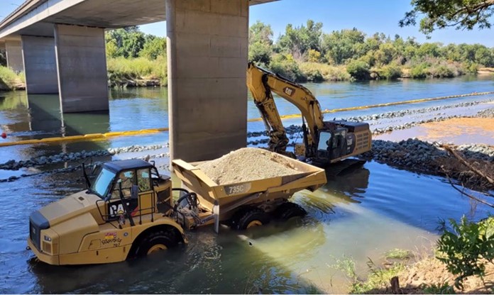
Sacramento River Erosion
USACE is also planning to further strengthen the levee system by constructing erosion protection measures along the riverbank. In all, it is anticipated that USACE will construct up to an additional 10 miles of riverbank erosion protection work. Once completed, the improvements will further reduce flood risk and meet current urban levels of flood protection requirements.
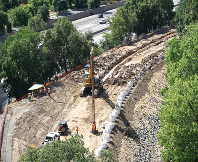
The northern area of Sacramento is protected by a series of levees and channels that include Dry Creek, Robla Creek, Natomas East Main Drain Canal/Steelhead Creek (NEMDC) and Arcade Creek. In the 1990’s, SAFCA implemented substantial improvements to the system. The improvements included construction of a new levee and pump station along the north side of Dry Creek, and levee raising and strengthening along the east side NEMDC, the south side of Dry/Robla Creek, and the north and south sides of Arcade Creek.
In the aftermath of Hurricane Katrina in 2005, state and federal agencies adopted new policies and standards to make levees safer. It was determined that parts of the system would require additional improvements to meet current standards.
In 2018, SAFCA constructed 3.75 miles of levee improvements along Arcade creek north and south levees west of Marysville Blvd and the NEMDC east levee between Arcade Creek and W El Camino Avenue. Additional improvements to be constructed by the U.S. Army Corps of Engineers are also planned along Magpie Creek.
Lower American River Erosion
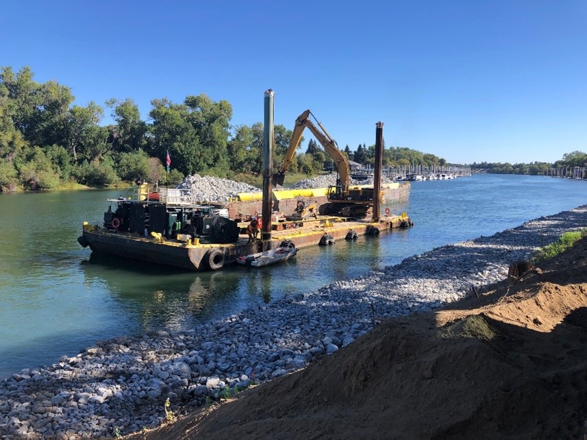
Since 2022 the USACE has been constructing approximately 6 miles of erosion protection along portions of both the north and south banks of the American River. This is critical along the American River where the channel has been severely narrowed and the erosion potential during large flood events is extremely high. Once completed, the cumulative flood control improvements will allow the levee system to safely handle sustained flows of up to 160,000 cubic feet per second in the event of an extreme flood event in the American River watershed.
The development of a system-wide flood management plan in the Sacramento Valley began around 1850. Up until the flood of 1909, flood management activities focused primarily on confining flows within the existing river channels. This was a period with frequent levee failures, including failures in the 1909 flood event. As a result, the State of California and Federal government decided that a bypass system was needed to divert waters from the main rivers during high flows to relieve stress along the levee system. The State approved the Sacramento and Yolo Bypass systems as part of the Sacramento River Flood Control Project in 1911. Congress then authorized the U.S. Army Corps of Engineers (USACE) to construct the remainder of the project in 1917 and incorporated it into the federal system.
The Sacramento Weir, completed in 1916, is situated along the right bank of the Sacramento River between the Yolo Causeway and the Garden Highway, approximately 3 miles upstream from the confluence of the American River and Sacramento Rivers. Its primary purpose is to protect the City of Sacramento from excessive flood stages in the Sacramento River by diverting river flows west into the two-mile-long Sacramento Bypass that connects to the Yolo Bypass. The Yolo Bypass takes 80% of the flood flows during storm events from major valley rivers including the Sacramento, American and Feather Rivers.
Just downstream of the Sacramento Weir is the confluence of the American and Sacramento Rivers. The design flood capacity of the American River is higher than that of the Sacramento River. During a major flood event, flows from the American River channel often exceed the capacity of the Sacramento River downstream of the confluence. When this occurs, floodwaters flow upstream from the mouth of the American River to the Sacramento Weir.
USACE, SAFCA and the State of California are widening the Sacramento Weir and Bypass to allow more water to enter into the Bypass system during flood events, thereby reducing the water surface elevation in the Sacramento River. This work includes widening the existing weir by 1,500 feet and constructing a new 2-mile-long setback levee along the Sacramento Bypass.
The first phases of construction began in 2020 when the State initiated construction of the Lower Elkhorn Basin Levee Setback Project, which includes widening the Sacramento Bypass. The USACE is constructing the widened weir, which includes a fish passage, and will connect to the levees constructed by the State.
-
American River Watershed Common Features Natomas Project
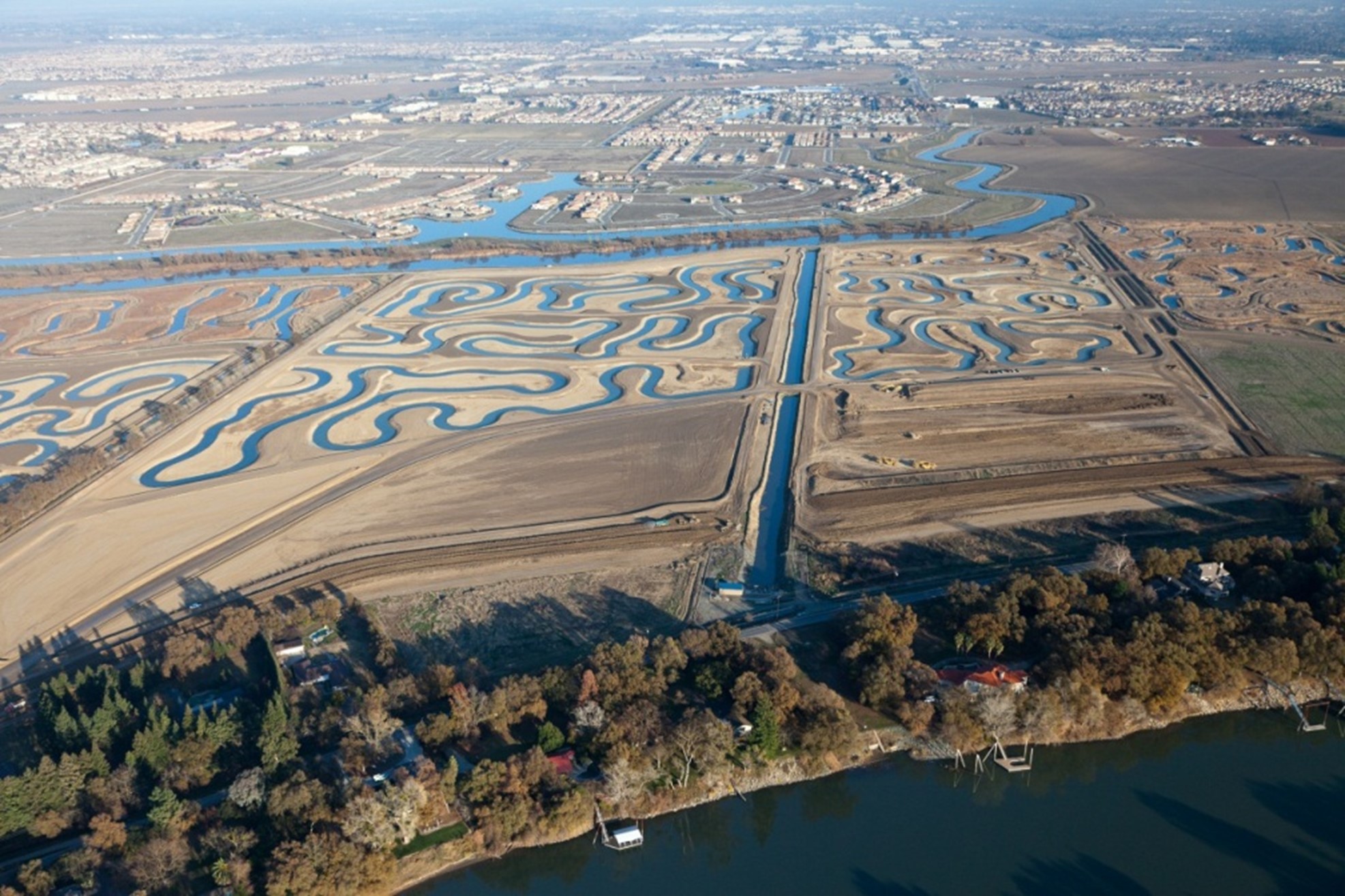
The Natomas Basin is surrounded by 42 miles of levees that provide protection from the American River, Sacramento River, Natomas Cross Canal and Natomas East Main Drain Canal. Improvements to the levees were constructed in the early 1990’s, which consisted of raising levees along the streams and canal systems. However, as other risk factors, including susceptibility to under seepage, began to generate increased concern, particularly following the 1997 flood event in the Sacramento Valley, it became clear that additional levee improvements would be needed in the Natomas Basin.
In 2006, the U.S. Army Corps of Engineers (USACE) determined the Natomas Basin had less than a 100-year level of flood protection due to the threat of deep under seepage. In 2007, SAFCA and the State of California began constructing levee improvements while USACE sought Congressional approval and appropriations for the work. These improvements included the construction of deep cutoff walls, landside berms, and a new adjacent levee along a portion of the Sacramento River East Levee to prevent under seepage.
By 2013, SAFCA and the state completed 18.3 of the 42 miles of levee improvements required to meet current flood control standards. In 2019, USACE began construction on the additional 24 miles of levee improvements necessary to increase protection to the Natomas Basin.
-
American River Watershed Folsom Dam Modification Project
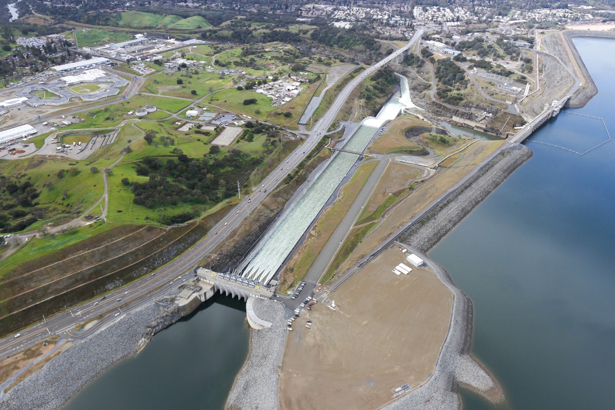
Completed in the mid-1950’s, Folsom Dam is the cornerstone of Sacramento’s flood control system on the American River. Considering larger flood events that occurred after its completion, it was recognized in the late 1980s that improvements to Folsom Dam and Reservoir, combined with improvements to downstream levees, were necessary in order to provide what flood control officials deemed a minimum 200-year level of flood protection to the Sacramento area.
A new dam and auxiliary spillway, called the “Joint Federal Project” or “JFP” (because the U.S. Army Corps of Engineers (USACE) and U.S. Bureau of Reclamation each constructed a portion of the project), was completed in 2017. The new spillway was constructed adjacent to Folsom’s main concrete dam and includes a 1,100-foot-long approach channel beginning in Folsom Reservoir with submerged gates embedded in a new control structure designed to discharge water down a 3,100-foot-long spillway chute. Because the auxiliary spillway’s gates are lower than those at the main Folsom Dam, dam operators are able to quickly create more available flood storage space in the reservoir in anticipation of increased inflows during storm events.
To further increase flood control space in the reservoir, the USACE is raising the existing main dam and reservoir’s surrounding dikes by 3.5 feet, which began in 2019.
-
American River Watershed Folsom Dam Raise Project
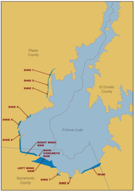
Folsom Lake is formed by the Main Concrete Dam, the Right and Left Wing Dams, Mormon Island Auxiliary Dam, and Dikes 1 through 8 as shown on the graphic. Completed in the mid-1950’s, Folsom Dam is the cornerstone of Sacramento’s flood control system on the American River. Considering larger flood events that occurred after its completion, it was recognized in the late 1980s that improvements to Folsom Dam and Reservoir, combined with improvements to downstream levees, were necessary in order to provide higher level of flood protection to the Sacramento area.
To further increase flood control space in the reservoir, the USACE is raising the existing main concrete dam and other three earthen dams and eight dikes that form Folsom Lake. The work includes a 3 ½ foot raise of the Right Wing Dam, the Left Wing Dam, and Mormon Island Auxiliary Dam, as well as Dikes 1 through 7. The Dike 8 raise was completed in 2020. The work on the Main Concrete Dam includes strengthening existing concrete dam and the strengthening and placing top seals on the existing spillway gates.
-
South Sacramento Streams Group Project
 Urban neighborhoods in the southern portion of the City and County of Sacramento rely on levees to protect them from foothill runoff and overflows from the Cosumnes and Mokelumne Rivers as well as from levee failures in the Delta just south of Sacramento (due to the topography, flood waters would flow north into the southern portions of the Sacramento area). Four local creeks in the area protect most of the neighborhoods, which include Morrison Creek, Elder Creek, Florin Creek and Unionhouse Creek.
Incremental improvements to the local creeks have been constructed between 1996 and 2017 by the U.S. Army Corps of Engineers, State of California and SAFCA. These improvements include the construction of 12.6 miles of floodwall, 7.7 miles of sheet-pile cutoff wall, 1.3 miles of new levees, raising 4.6 miles of existing levees and retrofitting 17 bridges.
The City of Sacramento is the most at-risk city in the country from riverine flooding, with more than half a million people in the flood-plain and more than $70 billion in damageable property.
Sacramento is at risk from flooding from both the Sacramento and American Rivers. The flood control system protecting Sacramento was completed in the mid-1950’s. It consist of approximately 106 miles of levees and channels within SAFCA’s jurisdiction. Upstream of Sacramento Folsom Dam controls the flows on the American River. The Sacramento River flows are controlled by the Fremont Weir and Yolo Bypass. Additionally, the Sacramento Weir and Bypass move water into the Yolo Byapss to make room in the Sacramento River for flows coming in from the American River.
The 1986 and 1997 flood events demonstrated that the existing flood control system was extremely undersized. Additionally, Sacramen-to’s levee system needed to be reconstructed to meet the new urban levee standards promulgated after Hurricane Katrina.
These six projects, costing more than $5 billion, cover reconstructing every portion of the flood control system protecting Sacramento except for the Fremont Weir and Yolo Bypass. These costs are shared by the Federal Government, the State of California and SAFCA.
The U.S. Army Corps of Engineers (USACE) is the Federal Agency responsible for implementing these projects. The U.S. Bureau of Reclamation owns and operates Folsom Dam and cost-shared a portion of the American River Watershed Folsom Dam Modifications Project (Joint Federal Project). The Central Valley Flood Protection Board and the Department of Water Resources are the agencies responsible for implementing and cost-sharing the projects for the State of California. Links to each agencies’ webpage are included.
There are currently six active Congressionally-authorized projects under construction.
- Additional Activities